


Aerial Photography for Archaeology
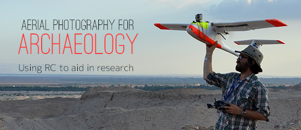
Using RC to aid in research Written by Austin “Chad” Hill Read the full article in the April 2014 issue of Model Aviation.
Model airplanes are my father’s lifelong hobby. As soon as I was old enough to hold a transmitter, he took me flying. Although I continued to fly with him throughout high school and college, I never expected RC aircraft to become a part of my professional life! Nearly 30 years later, I fly RC as an archaeologist collaborating on a number of excavations and archaeological research projects. Although RC technology is not new to archaeology, with the advent of multirotors, archaeologists have begun to realize the potential of small Unmanned Aerial Systems (sUAS) as low-cost aerial photography platforms. I have been working with Yorke Rowan, of the University of Chicago, and Morag Kersel, of DePaul University in Chicago, to use RC aircraft to document ongoing archaeological projects in the Near East.
Aerial Photography and Archaeology
Archaeologists have been using low-level aerial photographs to document their excavations for more than 100 years, beginning when Sir Henry Wellcome documented excavations in the Sudan in 1913 with a camera suspended from a kite. Overhead images of archaeological excavations are critical for recording the spatial relationships among archaeological features such as buildings, courtyards, burials, hearths, and artifacts, and they can sometimes reveal relationships between features that are not apparent from the ground. Modern archaeologists continue to use kites, as well as balloons, poles, fruit-pickers, construction equipment, and ladders for overhead photos. Unfortunately, these methods are often unreliable, expensive, or dependent upon serendipitous access to nearby equipment. Radio-controlled aircraft provide an affordable, flexible alternative.Equipment
For this past season I selected a Skywalker 1680 foam FPV model as a platform. This airplane has been fantastic. Durable and affordable, it flies predictably, can land on a variety of surfaces with its fiberglass belly pan, and can be broken down and transported in a relatively small box. We also routinely work with multirotors. Airplanes and multirotors provide different benefits for archaeologists. Airplanes are great for mapping larger areas more quickly and they are less prone to catastrophic failures; however, airplanes require more space to launch and land, are bulkier to transport, and are slower to deploy.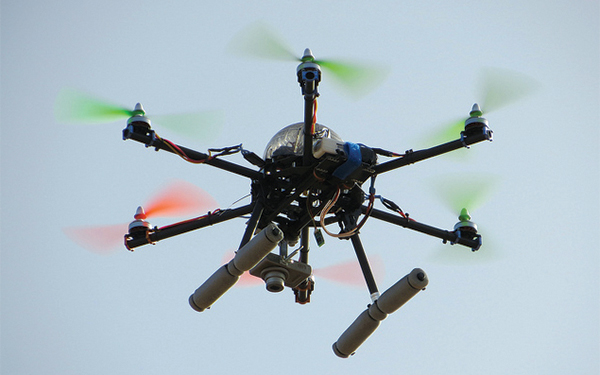
The camera is clearly visible as this hexacoptor flies at Wisad Pools, Jordan. Photo courtesy of Gary Rollefson.
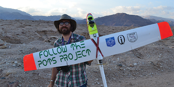
The author posing with the Skywalker 1680. Photo courtesy of the Follow the Pots Project.
Most of our surveys are performed using Canon S100 cameras. These cameras have decent resolution and can run Canon Hacker’s Development Kit (CHDK), an alternative firmware that gives you a variety of additional camera controls. The most important feature of CHDK is the ability to run intervalometer scripts that force the camera to take a picture every second or two for the entire time the model is aloft. We use an infrared-enabled camera for some surveys. Infrared imagery has the potential to reveal patterns of differential growth in agricultural fields that are invisible to the naked eye. These patterns might help us identify archaeological features below the soil that are not otherwise discernible.
New Technology: 3-D Modeling
Traditionally, archaeologists have used aerial images as simple illustrations of their excavations. However, the development of 3-D photogrammetry technology now allows us to convert standard two-dimensional photographs into high-resolution 3-D data. These models provide a visceral way to experience archaeological sites after excavations are over, so they can be a great resource for sharing our results with others, including students and the general public. Of greater importance, 3-D models can be used, along with some additional survey data, to generate accurate maps. Unlike the original photographs, these 3-D models are undistorted and properly scaled to the real world. We generate 3-D models on several scales.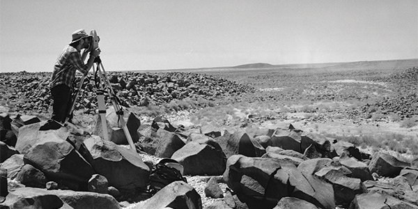
The author performs a terrestrial survey to record spatial data for 3-D modeling from aerial photos at the site of Wisad Pools, Jordan. Photo courtesy of Yorke Rowan.
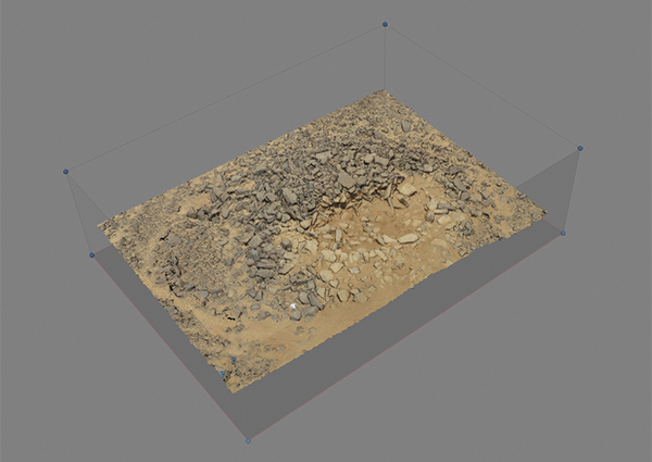
A 3-D model of a Neolithic dwelling at Wisad Pools, constructed from more than 100 aerial images of the structure. Photo courtesy of the Eastern Badia Research Project.
The 2013 Field Season
Last summer I had the opportunity to do aerial photography and mapping at several archaeological sites in Israel and Jordan. I will discuss two of them.
Wisad Pools
Wisad Pools is a massive archaeological site in the eastern desert of Badia in Jordan. The site consists of hundreds of collapsed structures, visible on the surface, spread across an area spanning several square kilometers. Use of the site covers a huge timespan—from approximately 12,000 years ago until the 4th century A.D.
At Wisad Pools, we used RC aerial photographs in several ways. First, we flew the airplane over large portions of the site in order to construct topographic maps of the area that show the exact locations of visible archaeological ruins. We excavated one of the prehistoric houses this season, and topographic mapping will help us place that structure in the wider context of the rest of the site.
We flew the airplane over the pools as part of a smaller project to map the location of several hundred rock art drawings carved into nearby boulders. These carvings generally depict wild animals such as those the ancient inhabitants would have hunted. Mapping these will provide clues to how people used the landscape.
Finally, we used the hexacopter, along with pole aerial photography, to take aerial photographs of the building we excavated. These photographs will be used to build successive 3-D models showing the different phases of construction of the structure, which was originally used as a house by people in the late Neolithic Period and then was reused as a burial monument thousands of years later. These 3-D models will allow an extremely detailed reconstruction of the early and late use of the structure.
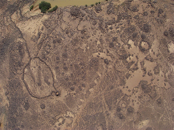
An aerial shot at Wisad Pools, Jordan, shows a pool at the top, a large animal pen to the left (circle with a V-shaped opening), and many remains of Neolithic structures (circular features in center and bottom). Photo courtesy of the Eastern Badia Research Project.
Fifa
Fifa is one of a cluster of five Early Bronze Age sites along the Dead Sea Plain in Jordan. Although it has only had limited archaeological study in the past, we know that it is a major burial center where thousands of people were interred between 3600 B.C. and 3100 B.C.
Since the early 1980s, an alarming number of these burials sites have been dug up and the burial goods sold on the illicit antiquities market, but researchers disagree on the scale and pace of the problem.
To help address the issue, Morag Kersel invited me to use UAVs as part of a long-term project documenting the damage to the site caused by illegal looting.
Throughout the course of several days, we flew several flights with our RC airplane to get comprehensive photographic coverage of the site as it currently exists. These photographs will be turned into a detailed 3-D model of the site. This model will allow us to map individual looting pits as well as the extent of the destruction caused by looting.
More significantly, when we revisit the site each summer during the next several years, we will make new 3-D models and track how the landscape changes as new looting pits are dug. The goal is that by documenting the scale of the problem we will be able to help protect these sites in the future.
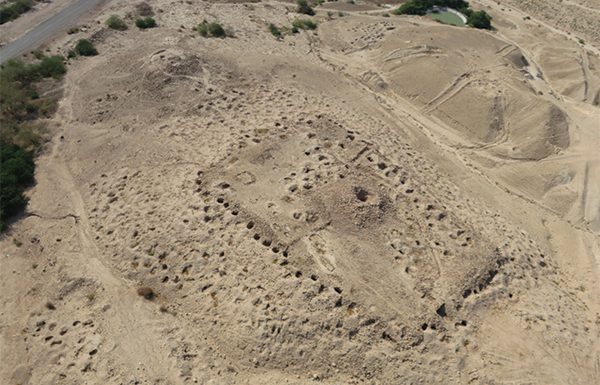
An oblique photo of part of the site of Fifa, Jordan. Every small black circle is a shadow in a looted burial site. Photo courtesy of the Follow the Pots Project.
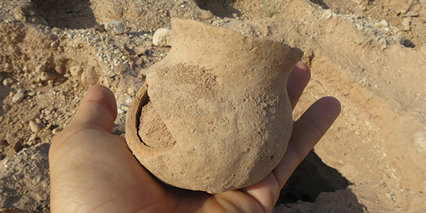
Remnants of looting include a broken pot left behind at the Early Bronze Age site of Fifa, Jordan. Photo courtesy of the Follow the Pots Project.
Conclusion
RC models can be a great tool for archaeologists looking for low-cost mapping solutions and 3-D modeling of archaeological sites, landscapes, and excavations. This is an exciting avenue for utilizing RC technology to support research endeavors, and it has been an exciting opportunity for me to combine two things that I love.
The next few years are likely to witness an explosion in RC use in archaeology and related fields. I look forward to continuing and expanding my use of these machines in the Near East and beyond.
—Austin "Chad" Hill
[email protected]
Bonus Photos
Sources
Skywalker 1680
www.hobbyking.com
GoPro
www.gopro.com
Canon
www.usa.canon.com/cusa/consumer/products/cameras
Follow the Pots Project
http://followthepotsproject.org
The 2013 Field Season
Last summer I had the opportunity to do aerial photography and mapping at several archaeological sites in Israel and Jordan. I will discuss two of them.Wisad Pools
Wisad Pools is a massive archaeological site in the eastern desert of Badia in Jordan. The site consists of hundreds of collapsed structures, visible on the surface, spread across an area spanning several square kilometers. Use of the site covers a huge timespan—from approximately 12,000 years ago until the 4th century A.D. At Wisad Pools, we used RC aerial photographs in several ways. First, we flew the airplane over large portions of the site in order to construct topographic maps of the area that show the exact locations of visible archaeological ruins. We excavated one of the prehistoric houses this season, and topographic mapping will help us place that structure in the wider context of the rest of the site. We flew the airplane over the pools as part of a smaller project to map the location of several hundred rock art drawings carved into nearby boulders. These carvings generally depict wild animals such as those the ancient inhabitants would have hunted. Mapping these will provide clues to how people used the landscape. Finally, we used the hexacopter, along with pole aerial photography, to take aerial photographs of the building we excavated. These photographs will be used to build successive 3-D models showing the different phases of construction of the structure, which was originally used as a house by people in the late Neolithic Period and then was reused as a burial monument thousands of years later. These 3-D models will allow an extremely detailed reconstruction of the early and late use of the structure.
An aerial shot at Wisad Pools, Jordan, shows a pool at the top, a large animal pen to the left (circle with a V-shaped opening), and many remains of Neolithic structures (circular features in center and bottom). Photo courtesy of the Eastern Badia Research Project.
Fifa
Fifa is one of a cluster of five Early Bronze Age sites along the Dead Sea Plain in Jordan. Although it has only had limited archaeological study in the past, we know that it is a major burial center where thousands of people were interred between 3600 B.C. and 3100 B.C. Since the early 1980s, an alarming number of these burials sites have been dug up and the burial goods sold on the illicit antiquities market, but researchers disagree on the scale and pace of the problem. To help address the issue, Morag Kersel invited me to use UAVs as part of a long-term project documenting the damage to the site caused by illegal looting. Throughout the course of several days, we flew several flights with our RC airplane to get comprehensive photographic coverage of the site as it currently exists. These photographs will be turned into a detailed 3-D model of the site. This model will allow us to map individual looting pits as well as the extent of the destruction caused by looting. More significantly, when we revisit the site each summer during the next several years, we will make new 3-D models and track how the landscape changes as new looting pits are dug. The goal is that by documenting the scale of the problem we will be able to help protect these sites in the future.
An oblique photo of part of the site of Fifa, Jordan. Every small black circle is a shadow in a looted burial site. Photo courtesy of the Follow the Pots Project.
Remnants of looting include a broken pot left behind at the Early Bronze Age site of Fifa, Jordan. Photo courtesy of the Follow the Pots Project.
Conclusion
RC models can be a great tool for archaeologists looking for low-cost mapping solutions and 3-D modeling of archaeological sites, landscapes, and excavations. This is an exciting avenue for utilizing RC technology to support research endeavors, and it has been an exciting opportunity for me to combine two things that I love. The next few years are likely to witness an explosion in RC use in archaeology and related fields. I look forward to continuing and expanding my use of these machines in the Near East and beyond. —Austin "Chad" Hill [email protected]Bonus Photos
Sources
Skywalker 1680www.hobbyking.com
GoPro
www.gopro.com
Canon
www.usa.canon.com/cusa/consumer/products/cameras
Follow the Pots Project
http://followthepotsproject.org
This Month's Issue

Join the AMA
![]()


1 comments
3D technology
Add new comment